

Public Realm
Quick Finder (Follow links for more information)
| Public Art [29/8/10] | Bath Abbey [27/2/11] |
| Bus Shelters [30/4/11] | Cycle Racks [18/9/11] |
| Electric Cycle Racks [31/7/11] | East Gate [7/10/12] |
| Firs Field [31/3/11] | Little Southgate [5/5/11] |
| Pavement Advertising [31/3/11] | Riverside Walkway [29/9/12] |
| Speed Limits [23/9/12] | St James Rampire [31/10/10] |
| Stothert's Crane [26/2/12] | Victoria Bridge [26/8/10] |
| Wayfinders [30/4/11] | As Others See Us [15/1/12] |
| Street Clutter [10/8/14] | Facadism [17/11/19] |
Public Art
 [22/8/10] It is recognised that water and Bath go naturally together, and public art incorporating flowing water is an obvious example of this. However, water plus sunlight plus wind-borne spores result in algae.
 When we discussed the Watchdog approach to public art planning applications, we recognised that installing water features should be accompanied by arrangements to keep them clean. That has not happened.
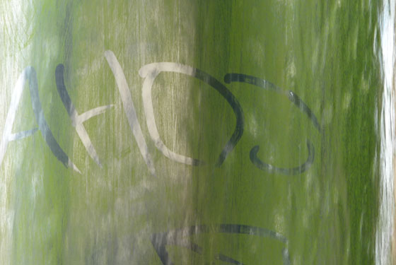
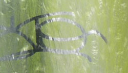
The public art in the small garden where Walcot Street meets London Street has now grown sufficient algae that graffiti can marked in it.
 Our pictures above and right show innocuous examples, but visitors to the site could read things from a different angle which are much more unsavoury.
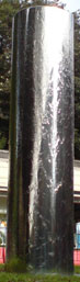
[29/8/10] And what a difference a week makes, as the picture on the left shows!
When we examined the public realm a week later we were pleased to see that the sculpture we had featured has been cleaned. Apart from a residual hint of green near the base, it is back to its original shiny condition.
We will keep an eye on it, because it will eventually host more algae if it is neglected again, but hopefully now that we have drawn attention to the problem, future cleaning will be part of a routine schedule.
Go back to top index
Bath Abbey
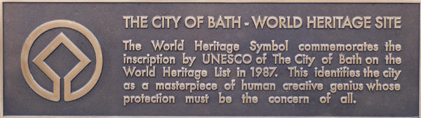 In September 2010 we published a news item under the heading World Heritage, which according to the information plaque in the Abbey Churchyard "must be the concern of all". We expressed our concern that the tourist views of the Abbey were not what they should be.
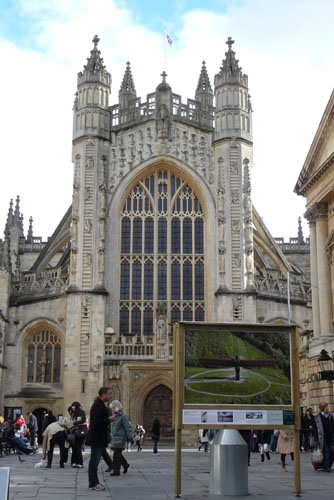
One of the most photographed places in Bath is the Abbey, and the preferred view is from York Street, by the wall surrounding the Roman Baths. The left hand photo below came from a local guest house "things to see" recommendation, and the right hand one from a photographer's "Scenes of South West England" on-line gallery, so it is not just our opinion.
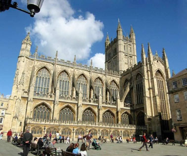
Would a tourist be happy with the photograph taken from there today; we asked, or would they go home disappointed, deterred by a photograph that could have been so much better?
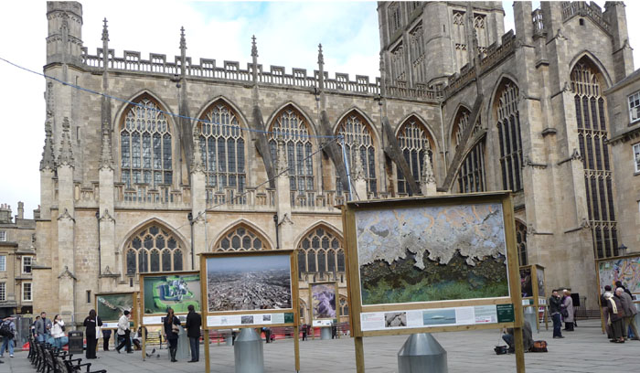
Within days of publishing that piece, we were e-mailed photographs from others who shared our concern, and we published the best of those pictures which describe visually much better than we could in words, just how much the visitor experience is being affected. With thanks to those contributors, we reproduce the photographs below.
At the time, we pointed out that there is a considerable amount of open space available in other locations, and in any case this exhibition will have to be moved for the Christmas Market, so why was it put in the Abbey Churchyard in the first place?
Time passed, and two things happened that reawakened our concerns about the appearance of the Abbey. The first was a planning application raised by the council (which we objected to), indicating a wish to use Kingston Buildings as a location for 29 picture stands and a shed to be used as a shop. The other was a question from a concerned reader: "Have you seen that thing they have stuck next to Rebekah's Fountain?".
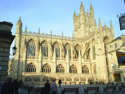
 So we went along with a camera to stand where the tourists stand, to take the photos the tourists take. We took a few others too, from slightly different viewpoints, one of which is on the right.
Aside from noticing that Rebekah's water jug has run dry and her plinth is growing algae, we couldn't find any position to photograph her without an array of pictures that have nothing to do with Bath in the background. Although people were looking at the pictures, nobody seemed to know why they were there.
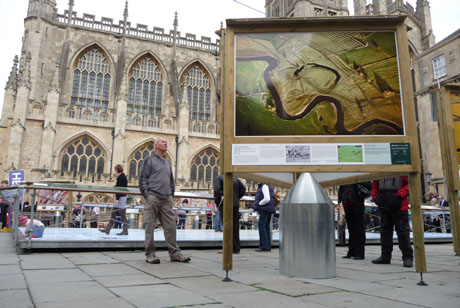
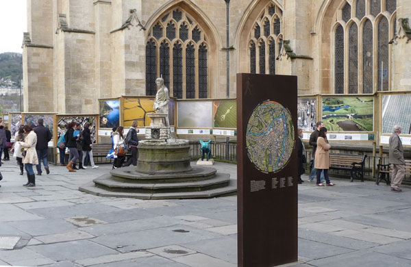
This photo shows what was described as "that thing". It is one of the new Public Realm Way Markers, with a map of Bath on it. It may have been placed there because that is where the Open-top Bus Tours stop, but it is edge on to the bus and one of the Tour Guides said that most people alighting from the buses he is on walk past it without noticing it. The only thing it really achieves is to get in the way of tourist pictures of the Abbey and Rebekah's Fountain taken from the traffic island. It is in entirely the wrong place. And for that, someone has dug a piece out of the historic paved surface to install it!
 In the background, behind the fountain, is a turquoise pig. There is no sign on the pig to say what relevance (if any) it had to the location, and it was being universally ignored while we watched. So why was it there, and what did whoever put it there hope to achieve?
Then we walked round to approach the Abbey from the Colonnade, and we stood where lots of tourists stand, because it is the best place to photograph the entire west end of the Abbey. On the right is what should have been that popular picture, completely spoiled by a photograph of The Angel Of the North, which is not relevant to Bath, and rather more than a day trip away if anybody is tempted to view it at first hand.
If the photographer stands further left, the north wing of the Abbey is out of shot, and standing further right causes the beautifully carved Abbey doors to be hidden by the irrelevant picture. We checked where the few people were now stopping with their cameras, on the Abbey side of the picture frame. Those photographs crop the smaller pinnacles on top of the Abbey from the shot, and require a wider angle lens to get the full height in the frame which somewhat ruins the perspective.
The frame with the Angel of the North picture didn't just appear there. Somebody authorised it because they thought it was a good idea. It wasn't.
Next we moved round to the view that started this item.
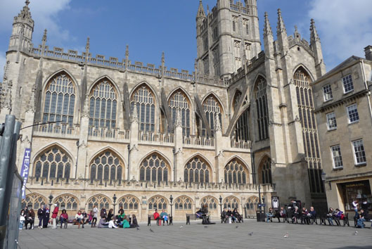
 It resulted in a photograph that is even more cluttered than the one that concerned us last autumn. It was a nice day and lots of people were walking around with cameras. Nobody but us took a photo from what had previously been the most popular location to do so. Our photo was taken standing up. When sat on a seat, even more of the view is blocked.
The other factor that seems to have been overlooked is that the Abbey is also a working church, with regular services and occasional use for special occasions like weddings and funerals. What the users of the Abbey think when they emerge from a religious service into an irreverent photographic theme park that pays no respect to their church, we can only guess at, but "inappropriate" is probably one of the milder thoughts in the minds of many.
Somebody obtained the mounted pictures that destroy the views; somebody authorised placing them where they are. We assume that they were well-intentioned and did not deliberately set out to ruin a popular tourist attraction. But they have. If you stand in one place for a while holding a camera and looking around, tourists assume you are also a visitor and give spontaneous opinions. These indicate that the pictures around the Abbey do more harm than good. The Way Marker was regarded more as an obstacle than an asset too. Clearly those who made the decisions to place these things where they are haven't understood tourists.
Nobody will make a special visit Bath to see a set of poster sized photographs. So those looking at them either live in the area and will look at the pictures out of idle curiosity, or they are visitors who have come to see Bath's attractions and they can't understand the point of Bath advertising locations elsewhere, particularly when these pictures are in unwelcome positions.
 What is more, the pictures that are in the way in Bath, advertise other tourist attractions which look delightfully uncluttered in comparison. How many people coming to Bath have now seen places that look attractive and preferable to a return visit to a Bath that "would be nice if only they knew how to look after it". Oh Dear !!
One of the ways tourists produce other tourists who visit, is when they go home and show their photos to their friends, some of whom might then decide they also want to visit Bath to see the sights for themselves. Doing anything to spoil or deter the taking of such photos, effectively cutting off free advertising, is going to be counterproductive. So we thought that when we took the photograph on the right on 17th March, common sense had returned.
When can we see common sense prevail?
Luckily, the Update Report correctly informed the Committee that the Bath Preservation Trust objected, despite their objection being filed on the planning website as a support comment. The vote on 16 March was sufficient to endorse the case officer's recommendation to refuse, although it also showed that a disappointing number of DCC members (along with the council department which originated the planning application) don't appear to properly understand tourism.
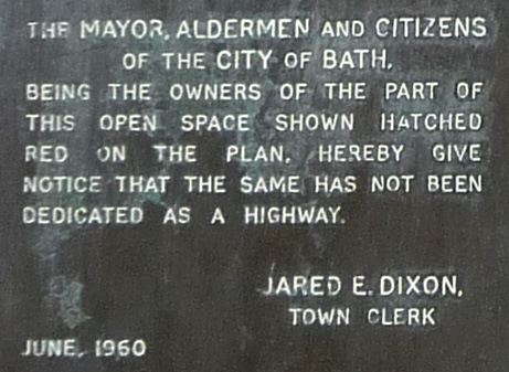
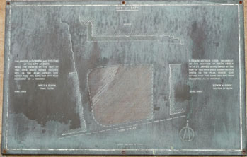 Equally disappointing is the council's assumption that they can do what they like with the open space outside the Tourist Information Office. So we have photographed the plaque in that part of the Abbey Churchyard (near right) and have magnified some of the words (far right) that show that the "CITIZENS OF THE CITY OF BATH" are very clearly stakeholders in what happens in that area. Equally pertinent are the areas on the map on the plaque that are not marked by hatching. By default therefore, these are dedicated as a highway by 50 years of custom and practice, and the constraints in the Highways Act 1980 now apply to them.
Then we started looking more closely at whether the approach suggested in the Chronicle's news item of "removing the elements that require planning permission" is possible. And what a can of worms that uncovered! The old saying that once you have opened a can of worms you can only put them back in a larger can has never been more true.
Temporary Buildings and Uses are identified by Statutory Instruments as "Permitted Development" subject to constraints, one of which is that the duration should not exceed 28 days and another is that the temporary use must not be for the display of an advertisement. As the exhibition is accompanied by a shop to sell copies of the displayed items, then the displays are arguably advertisements for the shop's products and not a simple exhibition. So wherever the displays are placed, they do require planning permission. (So, incidentally, did the exhibition just removed, for the same reason).
The idea now reported in the newspaper is to spread out the picture locations. The quote "across the city centre" places them in on-street locations, and that means the Highways Act applies, and that Act has rather different rules if it is the council instead of a business that is applying. The Highways Act says that before the council can apply for Highways permissions they have to obtain from every premises that they wish to place a display stand outside (called "frontagers in the Act) consent to placing it there, and agreement to the proposed use to which it will be put. Note that the Act requires consent to be "obtained": thus such consents cannot be assumed by a lack of an objection.
Even if such consents are obtained, most of the locations will have an impact on the setting of a listed building because the size of the displays will impede views of "features of special architectural or historic interest" and will therefore need listed building consent. There is nothing in the planning controls for listed buildings that exempts temporary displays.
In our opinion, that doesn't look like a can of worms that can be resolved by April 5th unless the exhibition is to be placed in an unlisted non-highway location (such as the Rec?). And all because an unguarded comment that the DCC refusal might be by-passed caused us to do the research.
No doubt the statement "removing the elements that require planning permission" made to the Chronicle by an unnamed spokesman was an unresearched wish but even so, no officer of the council should be advocating that the council breaks the law, because it appears that every element requires some form of consent if any part of the exhibition is placed on public land that is designated as a highway. And failing to obtain the necessary consents yet proceeding with the exhibition is a criminal (not civil) offence according to the Town Police Clauses Act 1847, which means that in would be individual officers (the Act say "Every person ..."), rather than the council as a public body, committing the offence and possibly facing prosecution.
 So what happened in April? Early in April, the Abbey Churchyard was once again cluttered with pictures totally irrelevant to Bath. The photo on the right was taken on 4th April. Most of the exhibition is installed in Kingston buildings, out of shot in this picture but shown in the photograph on our Enforcement page.
Apart from the destruction once again of the historic view, there is the impact on the setting of listed buildings, and a wonderful example of the council shooting itself in the foot. Planning officers have consistently (and rightly in our opinion) objected to trough lighting when it forms part of a planning application, and the refusal of planning permission for this exhibition specifically said that the means of illumination was unacceptable. Yet now the council has not only illegally installed photograph stands that it refused itself planning permission for, the stands have the specifically rejected trough lighting over each picture.
No doubt somebody will quote this exhibition in the future as a precedent for the trough lighting they wish to install on their listed building. What staggering thoughtlessness to undermine the authority of the planning officers in this way!
We had no option but to report the actions of Tourism, Leisure & Culture to Enforcement. We expect Enforcement to force this exhibition to be removed. Deciding it is not expedient to enforce is not an option, because no public body can be seen to condone an illegal act without itself being guilty of maladministration.
 June 30th 2011
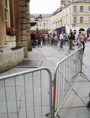
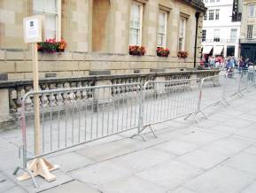 June 30th was to be a day of protest by public servants so we can understand some measures being taken to avoid confusion between protestors and visitors to the Roman Baths.
We were sent these photographs, and can only marvel at the expectation of visitor numbers that might need to be accommodated. The two people forming the entire queue in the far right photograph must have been something of a disappointment after all that preparation.
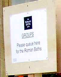 Of particular interest was the fairly insignificant sign (pictured in situ in the centre right photo above, and shown enlarged on the left) explaining the queuing system. It was not particularly prominent, and it was necessary to get fairly close before it became easily readable.
Also, in such a sensitive location, surely something a bit more decorative than the barriers that were installed could have been found? Whilst residents would have recognised the temporary nature of the barriers, visitors to Bath might have thought them the permanent feature (and given the tacky appearance of the cycle racks, who could blame them), to the detriment of their opinion of Bath
 On the 18th September we commented "This week marks the 6th Month anniversary of this exhibition being refused planning permission. It is still there (and being largely ignored by the public) despite it being reported to Enforcement when it was first
installed. The display along Kingston Buildings still has not been given permission under the Highways Act."
On the 18th September we commented "This week marks the 6th Month anniversary of this exhibition being refused planning permission. It is still there (and being largely ignored by the public) despite it being reported to Enforcement when it was first
installed. The display along Kingston Buildings still has not been given permission under the Highways Act."
 A week later, Union Street was clear (picture left) and one passer by was overheard to say to another "Doesn't it give a nice feeling of space now the pictures
are gone" which is perhaps a fitting epitaph for an exhibition that should never have been there in the first place. Kingston Buildings was similarly spacious (see picture right) and not as unused as our picture suggests; we waited a long time with a camera until we finally got this chance to picture it empty.
A week later, Union Street was clear (picture left) and one passer by was overheard to say to another "Doesn't it give a nice feeling of space now the pictures
are gone" which is perhaps a fitting epitaph for an exhibition that should never have been there in the first place. Kingston Buildings was similarly spacious (see picture right) and not as unused as our picture suggests; we waited a long time with a camera until we finally got this chance to picture it empty.
 Unfortunately the uninterrupted views of Bath Abbey that we had hoped for were not available on the day we took our photos (Thursday 22nd September).
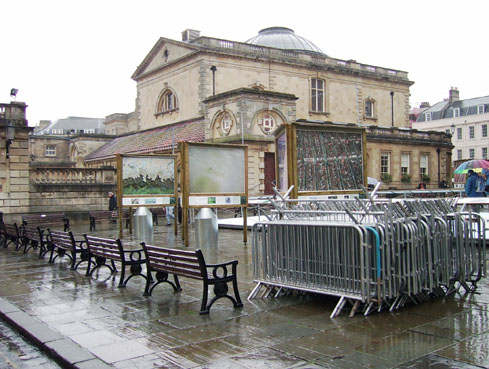
Occupying a large area between the Tourist Information Office and the Roman Baths was a fenced enclosure containing a large number of water butts placed inside what looked like the bases of the Wild Planet pictures. The water butts looked new, and there was no obvious explanation for why they were there.
When will the message get through to the people who regard the Abbey Churchyard as a convenient dumping ground that its value to tourists is at its greatest when it is empty (apart from pedestrians, seats and the occasional busker)?
Go back to top index
Bus Shelters
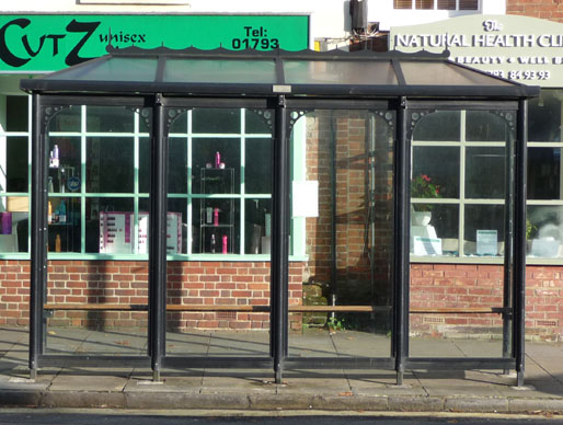
 One of our members has pointed out that there are two things that a waiting passenger expects a bus shelter to do: to protect from the rain, and to protect from cold winds. Only after these human comfort needs are met do the niceties like supplementary functions and style become of interest. With the aid of some photographs, Bath's shortcomings become apparent.
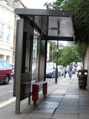
 The photograph on the right is one of the earlier types of shelter in Dorchester Street. It has a roof to keep the rain off, and a seat that requires continuous effort of the legs to remain seated, making it uncomfortable to use for any length of time and very painful for those with arthritic hips or legs because of the need to continuously resist sliding off. It has no side panels to protect from the wind.
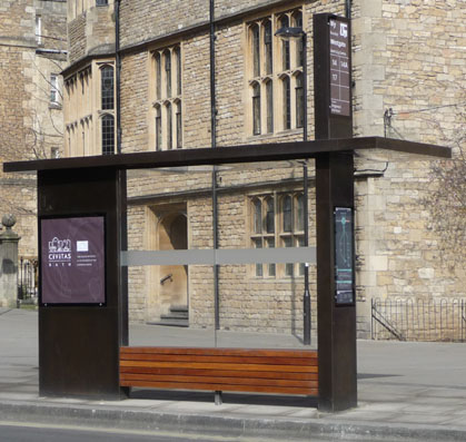
The photograph on the left is one of the new shelters that are appearing around Bath (this one is outside the Abbey Church House). Again it has a roof for protection from the rain, but no side screen to protect from the wind. It has a seat that is partly level but then curves away in a bullnose shape (perhaps to deter those who might otherwise sleep on the seat) so that there is no thigh support and most users would once again have to keep their feet on the ground in order to remain seated.
Neither of these models has any style that commends it to the World Heritage Site of Bath; in fact they are stark, bulky and angular, and when tourists see what is possible in other places nearby (see below) they cast Bath in a poor light, so the shortfalls in functional design cannot even be forgiven on aesthetic grounds. It is only a matter of time before the gulls discover that the buses are big but not hazardous and therefore the flat roofs could make a useful nesting site.
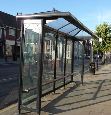 We were sent the pictures on the right and below for comparison purposes, and were told that the photos were taken in Wootton Bassett. They are two views of the same shelter.
 If anything, the seat is worse than the Bath one, but that is the only real drawback and one that could be relatively easily rectified. The practical benefits are that the construction is modular: This particular example has four panels between five uprights but elsewhere in the town are three panel and five panel examples for those locations where a greater or smaller number of passengers are expected to wait. The pitched roof and saw-tooth ridge give the face-on view some character as does the pierced metal arch at the top of the side panels.
Compared to the Bath examples it is better functionally, it probably uses less raw materials which is likely to make it cheaper, and it looks elegant enough to be acceptable in sensitive locations.
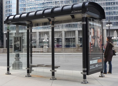 Our final picture on the right was clipped from one of the photographs brought back from the visit to the University of Notre Dame. The three things to notice here are the full width transparent front windbreak so that the bus driver can see if anybody is waiting, the extended rear windbreak which doubles as an advertising hoarding, and the modular construction so that different numbers of panels can be used depending on the demands for shelter space.
Particularly interesting though is the idea that seats need only be sufficient in number for the needy to sit down, but they do sit down in comfort on level seats offering thigh support. Small ridges between the seating positions are sufficient to prevent anyone attempting to lie across the seats, without inconveniencing those sitting down as intended.
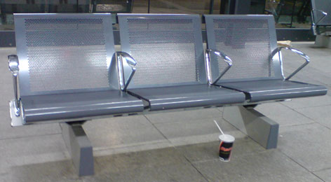 The final bad example is the seating provided at the bus station (this one was photographed inside, but the ones outside in Dorchester Street are identical). The protection from the rain is a metal panel so high overhead that unless the rain is coming straight down it is ineffective. There is no shelter from the wind. In the summer, the seats are comfortable. In the winter, the full stupidity of ordering metal seats is immediately obvious to anybody attempting to use them. Whoever chose this product should be sentenced to sit in one in the middle of winter until severe frostbite teaches them the lesson that their imagination seemed incapable of predicting.
It is probably too late to alter the shelters and seats that were recently installed, and we can only hope that this insight into what is possible is in time to avoid the current design failures being replicated everywhere in Bath.
In the case of functional street furniture, wouldn't it be nice if just occasionally someone would do the research to find out what would be best for Bath before ordering anything, rather than choosing something and waiting for the almost inevitable feedback that the choice wasn't good enough. In this case the result is bus shelters that have usability issues (which suggests that the person responsible doesn't use buses often!), and an appearance that whilst not particularly ugly, falls far short of what anybody would consider elegant.
 Footnote
Just for fun, we offer this photograph of a bus shelter photographed in Midsomer Norton, showing that functional doesn't have to be dull.
Whilst not recommending this style for the historic centre of Bath, we do note that Midsomer Norton, like Royal Wooton Bassett, has opted for a modular design that can expand or shrink to meet the expected usage. Bath's "heavy engineering" approach is looking more and more inappropriate.
Go back to top index
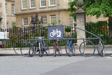
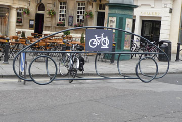
Cycle Racks
We have spotted and photographed a new style of cycle rack that has appeared at various locations around Bath.
In the following photograph set are:
Top row, Milsom Street (left) and Queen Square (right)
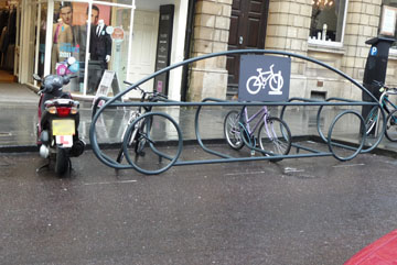
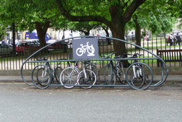
Bottom row, Westgate Buildings (left) and Sawclose (right)
We think they are likely to be contrary to road regulations. Motor vehicles have had to be fitted with reflectors for many years, so that when parked and unlit they are clearly visible to motorists approaching them. Other obstacles in the road such as skips, have by law to be fitted with lights at night to make them visible. Logically, the new cycle racks should also be illuminated at night because they occupy space on the carriageway and need to be made visible. The council's legal position should a vehicle collide with one of these cycle rack placed on the road without suitable warnings of its presence is not at all clear.
The positions where the cycle racks have been placed are where anybody placing a car there would have received a ticket for a parking offence. The most serious one is in the Sawclose where the cycle rack has been placed on a bend on double yellow lines. If it considered to be such a hazardous position that parking is forbidden "at any time" then the cycle rack and every cycle in it is committing a traffic offence. Any location not suitable for a car, is not suitable for a car shaped cycle rack. At the time we took our photograph, there was a workman's vehicle parked opposite it powering a pump to clear a blocked drain, and getting between the van and the cycle rack was a squeeze for an ordinary sized car; a delivery lorry would not have got through until the drain clearance finished. We couldn't help noticing too that the cycle racks that the Theatre Royal had to install as a condition for planning permission for their enlarged foyer were popular and well used compared to the one in the street.
The other locations are all resident's parking bays though two of them could also be used as pay and display spaces as well, so the rack and every cycle in it should have been booked for not displaying a valid permit or ticket. Previously there were cycle stands on St James Rampire, which appear to have been removed, yet they were in the pedestrian area and therefore much more appropriate than what has apparently replaced them. Putting in the cycle stands on St James Rampire then taking them away again shortly afterwards is a criminal waste of money, regardless of where the money comes from.
Now consider where they have been placed. Queen Square is a John Wood masterpiece. The cycle rack is mercifully on the gardens side of the road rather than right outside the buildings, but arguably it still has an impact on the setting and environs of listed buildings. Milsom Street is probably the most prestigious and well know shopping street in Bath, it is full of listed buildings, and yet the cycle rack is separated from the shops by only a narrow piece of pavement. It is definitely within the the setting and environs of listed buildings. Westgate Buildings is much altered from its original design, but the cycle rack has been placed just along from Chandos House which is listed as John Wood's first major work in Bath, and outside St John's Hospital, and just along from Abbey Church House. So this location is within the setting and environs of listed buildings. The fourth location, Sawclose is a Scheduled Ancient Monument, and also contains the listed and famous Theatre Royal. Listed building consent was not applied for for any of these locations.
The final concern is that these cycle racks are bolted to the road surface. If they are struck by a vehicle the mountings will be ripped from the road damaging the surface (and the rack itself would probably be damaged beyond further use, but that can be considered a hidden benefit). If they are unbolted, unless the bolt holes are sealed, rain will get in and in winter it will freeze and break up the road surface. Either way such events would leave another set of potholes to be filled.
We are not interested in a witch hunt, but somebody was responsible for the decision to buy a design that might be acceptable in a children's playground but not in the much photographed streets of a World Heritage Site; and somebody ordered them to be placed in the locations chosen. Why did nobody have the wit to stop them? We don't think they are lawful, and the sooner they are removed the less likelihood there is for the council being held liable for accident damage. "Action this day" as Winston Churchill used to demand.
Go back to top index
Electric Cycle Racks
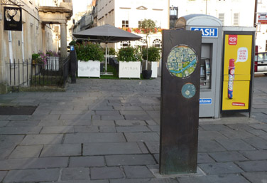
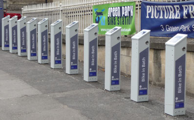 A new type of cycle stand has appeared. So far we have noticed one outside the Holburne Museum, one outside the south side of the Guildhall and one (pictured) outside Green Park Station. And look at the green sign in the picture which announces green park Bike station fixed to the listed railings of a former railway station.
All of these are listed buildings and all the stands should have secured listed building consent because they affect the environs of a listed building. No such applications were raised.
It was not necessary to spoil the tourist photos of the landmark listed buildings either. The Green Park stand could have been placed outside the unlisted Kingsmead House. The Guildhall stand could have been moved along to Manvers Street where the entrance to the GPO site by the police station could have accommodated it. The Holburne one could have been placed at the bottom of Bathwick Hill opposite St Mary's Church where it would only have spoilt the view of some railings and trees.
 Now look at the impression they give the tourists. On the top of each post is a set of instructions for use, and it is inevitable that passers by will read them to see what they say.
The language is poorly chosen. It bears all the hallmarks of a bad translation from another language. APPROACH THE CARD it says. Even native Englishmen might have to stop and think what it means. Now picture an overseas tourist with a limited grasp of English. It isn't a card, it is a post, and they have already approached it or they wouldn't be able to read it. SLOW BEEP WAIT it says. How many will interpret that as an instruction to wait for a slow beep rather than waiting if a slow beep is heard? THE BICYCLE IS DOCKED it says. How does that happen, when docks are a waterfront feature and the river is some distance away? Combine it with green park Bike station sign which grammatically should have an upper case G and P and a lower case b and they might wonder why what they are reading differs from what their English teacher taught them.
What sort of impression does it give when a World Heritage Site gives the impression that its signs are written by someone who is illiterate? One of the things that is essential in order to create the right impression of a tourist destination, is attention to detail. Yet somebody authorised the installation of instructions in broken English on posts that are positioned to spoil "must take" photographs. Whoever that was has let down Bath. Badly.
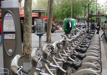 The picture below left is of a similar installation (albeit abroad) showing the
bikes in place. Imagine that outside listed buildings!
The picture below left is of a similar installation (albeit abroad) showing the
bikes in place. Imagine that outside listed buildings!
The cycle racks have also (in our opinion) created a problem for Enforcement, who should now be instructing their managers to remove those currently installed because they are unlikely to receive Listed Building Consent for those locations. Now someone has to decide whether to correct the problems, which will cost money now, or leave them so that word of mouth reports say that Bath is over-rated, which will cost income long term. Heads you lose. Tails you lose too.
These issues could have been avoided if there had been proper consultation before any plans were finalised. Native Bathonians would have identified the flaws in the plans if given the opportunity. So perhaps that is why they were not asked?
The bikes arrive
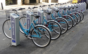 Heralded by a Chronicle news item, some of the bikes arrived to test the systems before the public launch in the last week in September 2011. The bikes are mercifully smaller than our picture above, see picture right, but not what the early publicity had led the public to expect. This is how the public were informed at the end of 2008:
"The scheme, which would also see Bath firm Powabyke supplying electric cycles, is one of a number mooted for the city centre which would be partly funded by cash from the European Community. ...
The council is working with Powabyke and Italian company Bicincitta on the cycle hire system which would allow people to rent bikes from cycle parks at spots across the city such as park-and-ride sites, the new SouthGate bus and railway station complex and the city centre."
The bikes we saw were not electric, nor do the stands appear to provide charging facilities for them. The locations for the bike stands do not include park and ride sites, nor Southgate. Nor indeed Lower Weston, Larkhall, Oldfield Park, Twerton, Southdown Combe Down or the University campuses which have far larger populations. Green park is convenient for Sainsburys and Orange Grove for Waitrose, but where are the facilities for Tesco in Lower Weston and Morrisons at Grosvenor?
Now look at the practicalities of what has been provided:
• The usage arrangements offer an annual pass, a weekend pass or a daily pass. These must be primarily aimed at residents, because tourist coaches drop day tourists close to the places they want to visit, so they won't need bikes. The tourists that Bath hopes to attract are those that stay for a week or longer, and they would expect to have the option of a weekly pass. Residents who want to cycle, by and large already do. Residents who don't want to cycle will be unlikely to be tempted to use these facilities, given the disadvantages below.
• The bikes in the racks have a 3-speed hub gear, which will be perfectly adequate on reasonably level ground and gentle hills but anybody fit enough to ride up Bathwick Hill or Lansdown Road or Wells Road will have got that fit by riding their own bike, and the majority of those will have at least five gears and perhaps as many as fifteen or more.
• The bikes have lights which illuminate while the bike is in motion, which is a good thing. Unfortunately the lights go out when the bike is stationary such as at traffic lights, which is illegal after dark. As it gets dark mid-afternoon around midwinter, this is a serious usability defect.
• A daily "unlimited travel in Bath" bus ticket costs less than the initial outlay for obtaining a daily pass to use a bike. The bike usage costs escalate rapidly with time, acting as a deterrent to even medium length journeys, especially if they involve a slow trudge up a hill pushing a bike.
• The racks are all relatively close together and in the centre, and easily walkable distances apart. Nobody will use a bike often between these destinations. What happens if the borrower arrives at their destination rack and finds it full so that they can't leave their bike there? Time could cost them money if they have to go to a different rack, even if the distances are small.
• There are no apparent facilities for securing the bikes if somebody borrows one and wishes to park it while going into a shop. If locking facilities are provided they would have to be all the same so that any user can use any bike. Thus any previous user will have the ability to unlock any bike seen parked outside a shop and ride it away at the original borrowers cost. If the bike is stolen because there is no means of locking it or an easily overcome means of locking it, who is responsible? If it is the person borrowing the bike, then each potential borrower would have to carry a bicycle securing lock and chain in case they leave the bike anywhere other than in the special racks. Impulse use is therefore ruled out.
• It doesn't say on the Bike in Bath website whether or not the borrower is responsible for any damage to the bike in the event of an accident. Yet these bikes are likely to be used mainly by people who don't ride bikes regularly and therefore might not have the awareness of danger that a regular cyclist acquires. And these inexperienced cyclists are likely to be inclined to ride on the pedestrian surfaces because the roads and traffic scare them.
This looks like an idea that hasn't been properly thought through; a potential white elephant, and one that already detracts from the environs of listed buildings without listed building consent.
Go back to top index
Eastgate
In the 4th October 2012 edition of the Chronicle is a description of a scheme to develop "The Colonnades" but it is not the place that those of us with long memories remember as the Colonnades, where British Home Stores now is, but the area under Grand Parade overlooking Pulteney Weir, and to avoid confusion we have used the arbitrary name of Eastgate (taking a cue from Southgate) for that location. The scheme was not discussed with Watchdog, so we can only comment on the sparse details that have been published.
It was not very long ago that the Eastgate area was accessible to the public. It was a pleasant and well-used walkway extension to the Parade Gardens, and theoretically also open to anyone walking through the East Gate, except that usually the door at the end was locked to ensure that it was not used by those wishing to visit the Parade Gardens without paying at the kiosk. Then things changed. A locked iron gate prevented public access to the East Gate, and barriers were put up to prevent rough sleepers using the area under Grand Parade, thwarting many (but not all) of the rough sleepers, whilst removing a well liked haven from the options of visitors to the Parade Gardens. If there were good reasons for those interventions, they surely haven't gone away now?
 There are other complications too. Since the access to the area was closed off, a spring has erupted through the stonework, as can be seen in the photo on the right.
 To put the picture in context, there is a wider view on the left. Whether by coincidence or as a direct result, this new spring started some months after the spring under Churchill House was sealed in order to build the busometer. There is a lot of water pressure behind a spring and often the result of blocking one is to create another somewhere else. Whether this one can be blocked or whether it can be piped away will be a problem to be solved before this area can be brought back into use; and if it is blocked, will it reappear somewhere else even less convenient? Also, has it already started to rust the supporting structures for Grand Parade?
The next issue is how this area would be brought back into use. First of all, Newmarket Row is all listed, so although change of use is possible, extensive alterations as suggested by "leisure facilities" would be problematical; and there are existing businesses trading there that might not survive these grandiose plans. A business thrives partly because of what it does and partly because of where it is. This is demonstrated by Bath Photo Optics which traded happily for 12 years in the Podium and lasted less than 12 months when it moved to Abbey Gate Street. In these financially stretched times, it is wrong to take a gamble with other people's livelihoods.
Then there is the proposed new use for the area: shops, cafes, restaurants and market stalls. The things all these have in common is deliveries and the removal of waste, and other than hoisting everything over the balustrade from Grand Parade, the only route for goods is through the East Gate. This is the last surviving original City gateway and putting it at risk of damage from delivery vehicles is totally irresponsible. If any of the proposed uses requires construction plant then (assuming that they can get past the entry control system for the Guildhall car park) the East Gate is especially at risk.
Finally we have to question the viability of cafes and restaurants in this location. In the surrounding streets there is a very high density of cafes and restaurants, and in business terms Bath must be already near to saturation point. Each new catering establishment that has opened recently seems to be accompanied shortly afterwards by news of one that closes, so the current assumption that "more is better" seems to be badly flawed. Meanwhile, the fate of interesting independent shops like Bath Photo Optics, the type that once gave Bath a character now being rapidly eroded by "High Street, Anywhere" outlets, is ignored. Bath can't rely just on tourists making their first visit to Bath, it needs them to come back again and again, and it will be the unique character shops that encourage them to do that, not multiples and franchises and places to eat, all of which can be found anywhere.
If the council can actually afford the multi-million pound price tag, then there are more deserving things to spend the money on. If a developer is sufficiently convinced that the scheme can be profitable to fund it, then is the peripheral damage to the existing businesses facing new competition a price worth paying?
The newspaper article suggests that there will be a consultation exercise and if so Watchdog will examine the consultation documents. But the fact that the search for a development partner appears in the same sentence suggests that the outcome is already pre-determined.
Go back to top index
Firs Field
There has been, in the past, some speculation about the status of Firs Field, so Watchdog did some research. We discovered that the condition of the land known as Firs Field is fixed by covenants recorded in the Land Registry records.
Funds to purchase the land were raised by public subscription. That subscription had two objectives:
• For part of the land to be used for an Ecclesiastical Charity by Combe Down Parish Church;
• For the remainder of the land to be gifted to the Parish Council for use as a Recreation Ground.
Accordingly, the land was purchased on 3 March 1919 by the Vicar of Combe Down Parish Church for £750. The vendors imposed a covenant, which the church agreed to:
• Not to keep pigs on the land;
• Not to erect any buildings unless it is to be used as a library or an institute, or one to use as a pavilion appropriate for a public park or recreation ground.
On 9 February 1920, the land was divided in accordance with the wishes of the public subscription, and the majority of the land was conveyed to Monkton Combe Parish Council. The council agreed to binding covenants:
• For the Council and their successors to use it for ever for the purpose of a public recreation ground;
• For the Council and their successors for ever hereafter to support, maintain and improve the land conveyed as and for the purpose of a Public Recreation Ground.
On 10 February 1920, the remainder of the land was conveyed to a Trust, with the Vicar and two Churchwardens as Trustees. The Trustees were required to let the land to the Church Army, and when the time came that the Church Army had no further use for the land, it should be gifted to Combe Down Parish Council in trust for the perpetual use of the inhabitants of Combe Down as an addition to the Public Recreation Ground.
On 1 June 1965, the successors to the original Trustees accordingly conveyed the land to the Parish Council of Monkton Combe.
Local Government reorganisations have since placed the assets of Combe Down and Monkton Combe in the hands of B&NES, but as all the covenants stipulated the Parish and their successors, B&NES is also restricted by these covenants "for ever".
Thus Firs Field must be maintained for ever as a Public Recreation Ground.
Go back to top index
Little Southgate
At the end of May we were alerted to street clutter of a different type, in Little Southgate. Our informant told us that the pedestrian path through Little Southgate is so strewn with trip hazards that he had no idea what the shops there had for sale because all his concentration was on watching what he was about to walk into.
 We went along and took photographs. Down the centre of this arcade are litter bins, alternating with what we assume are seats (pictured), plus a couple of advertising panels on stands (it didn't take long for those to appear, did it?).
The seats are low, mid-shin height, metal clad with sharp edges. We heard one passer-by joking to another that they look as though they came from the Isle of Man. It is not obvious how they are supposed to be used, because if one person sits in the centre of an arc, there is not enough room left for anybody else to sit down. But would people naturally sit on one of the three ends so that others had room to sit? We don't know because while we watched, nobody used any of them. Our assessment is that they are too low for the infirm to use because it would be difficult to rise again afterwards, and without a back rest there must be some possibility of the infirm falling off backwards if they did sit down.
Because of the layout, it is possible to walk past a litter bin but close to it, and then trip over a seat. We measured, and the seat height is below the average knee, so these are a definite trip hazard. The top edge is a sharp angle and could therefore cause a cut if anybody should walk into one, even if they did not trip. Certainly while we watched, passers-by were visibly wary of them, and very few were looking in the shop windows; instead they were making very sure they didn't walk into the seats. As a feature of a shopping centre, they are surely counter-productive.
We think that the current Health and Safety legislation would find them hazardous. The "No Win No Fee" lawyers must be rubbing their hands with glee in anticipation of the business to come ...
 Alternatives
We asked friends and relatives in other parts of the country for examples of what public seating arrangements they had for their covered arcades, and we were sent the photo on the right, taken in the High Chelmer Shopping Centre in Essex.
Here we have a seat for 4-8 people depending on how slim they are, at a comfortable height, with a back-rest that doubles as a planter for some soft landscaping.
 If tourists had seen this or other similar products elsewhere, they must wonder what made Bath choose such an impractical design for Southgate when better ones are available and used in other parts of the country. We wonder that too.
We also wondered how anyone who used the seats in Little Southgate would actually sit. We waited a long time to photograph one in use, and finally we did (picture left): a member of the public sat down - right in the centre. So now we know that each seat is likely to only seat one !
Go back to top index
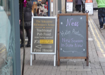
Pavement Advertising
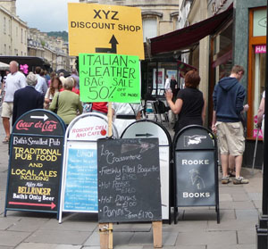 The Chronicle published an article enthusing about the restoration of Northumberland Place. Normally we would wholeheartedly have supported such initiatives, and indeed Northumberland Place does look much better after the effort lavished upon it.
But oh dear! The make-over has been accompanied by a forest of "A" Boards in Union Street, which not only looks tacky, but are a positive hazard to navigation, as a brief period of observation proved. They are an obstacle to mothers with push chairs, they forced a rather tricky detour for one user of a mobility scooter trying to go in the opposite direction to a tide of oncoming pedestrians also diverting around the obstacle. A pedestrian more interested on texting on a mobile phone than watching what was ahead almost tripped over them. All in 10 minutes.
Residents know what is along Northumberland Place, and tourists are more likely to explore out of curiosity than if they are faced with garish advertisements (that actually only cover some of the businesses) which cheapen the exploration experience and degrade photographs.
At the end of July 2010 we did a quick one-day mid-week count of "A" Boards in the main tourist areas: Stall Street through to Milson Street, Upper Borough Walls to Argyle Street and around the Abbey. We counted 120 such advertisements, which is a ridiculously large number for such a small area.
It is time these were controlled, perhaps by requiring advertising consent for any in a Conservation Area, which seems a reasonable approach rather than treat it as a criminal issue; yet it is a criminal offence, under the Town Police Clauses Act 1847, Section 28: "Every person who places or leaves any furniture, goods, wares, or merchandize, or any cask, tub, basket, pail, or bucket, or places or uses any standing-place, stool, bench, stall, or showboard on any footway, or who places any blind, shade, covering, awning, or other projection over or along any such footway, unless such blind, shade, covering, awning, or other projection is eight feet in height at least in every part thereof from the ground ..." for which the penalty is a fine or up to 14 days in jail.
In March 2011 the council launched a consultation on what they called an "Obstructions Policy". This consultation which sought to control temporary advertising such as "A" Boards under the Licences & Street Trading arrangements proved difficult to find. We found it (eventually) on the council website, and evidently so did the Chronicle It has disappeared since then.
The proposed policy looked unnecessarily complicated: applications for a licence, consultations with neighbouring businesses and residents, and with ward councillors, with objections being referred to a council sub-committee, all under the Highways Act, where decisions are not required to take account of the appearance, its effect on the character of the street scene or the impact on the World Heritage Site. The Highways Act only considers the potential impact as an obstruction, so it is inappropriate as the only means of control. There would be an application notice displayed, but there is no on-line facility to view the application, nor an on-line comment system so every representation would be in writing and would need to be filed. Given that the council is claiming to be short of money, this looks like an expensive administrative nightmare when multiplied by the number of "A" boards likely to be applied for: in our last survey (last August) we counted 120 in the central area alone. According to the Chronicle article, if a business gets a permit and breaks the terms they could be fined, but a business which doesn't get a permit escapes a fine and only suffers the possible confiscation of their board. How odd!
We do think that obstructions such as "A" boards need to be controlled, but we cannot support the approach being proposed. Something that does not cause an obstruction can still have an appearance that destroys the photographic potential of a street scene.
So in the hope of injecting some alternative thinking into this well meaning but dreadfully limited scheme, we suggest that existing Town & Country Planning Act arrangements are used instead.
• Issue an Article 4 Direction banning "A" boards and the like in Conservation Areas unless specifically permitted.
• Then require any business that wants an outside advertisement like that to raise a planning application for Advertising Consent. Such an application would automatically be notified to neighbours by the display of a planning notice and an entry in the Weekly Applications List, the planning system makes provision for ward councillor notification, for public comment, and a decision, taking into account all the local plan policies not just the impact on the highway, would be made by a case officer or in exceptional circumstances by the
DCC.
• Any permission granted could contain a standard clause also giving the necessary permission under the Highways Act, but also contain conditions about location and times of display, and where appropriate, colour and design. Infringements of the conditions can be pursued as Enforcement cases.
It is not rocket science, is it?
During April, the subject of "A" boards sparked a lively debate in the Chronicle, appearing in the April 14th issue, the April 21st issue and the April 28th issue. From the April 21st contributions we learn that the idea of a licence is being dropped. We hope that this does not mean that the whole question is going to be considered too difficult and nothing will be done.
On 21st May the Western Daily Press published a letter on street clutter. We have no connection with the letter writer, but we have been saying similar things for some time, though perhaps not so eloquently as the following:
Bath needs a clear response to clutter
I have an interest as a Bathonian who negotiates the city centre weekly on Saturdays pushing my mother in a wheelchair from Westgate Buildings to the Post Office and Waitrose.
It is a route fraught with difficulty, not only because of the many unnecessary and inappropriately placed A-boards but also because of the use of granite setts in pedestrian areas, the lack of dropped kerbs, creeping outdoor café tables and chairs, uncontrolled street performers and the ubiquitous people paid to stand holding adverts.
Union Street is the worst for all these hazards.
However, it does not have to be this way. Last week I visited three other UNESCO World Heritage cities: Trogir, Split and Dubrovnik (all in Croatia). The contrast between these sophisticated cities and Bath is staggering.
Last Saturday Bath appeared as a dirty cheap, grasping, poor cousin, with pretensions of being a circus. Yes, the set pieces are truly impressive, but let's get rid of the unnecessary clutter and tat so that the rest of the city centre has the chance to absorb some of the class.
In Dubrovnik, wall-mounted banners are placed at each end of a street, listing all the traders in the street and what they sell.
In any event canny tourists around the world know that the best shops, treats and bargains are often found in the side streets, so there is no need for any of these obstructive A-boards.
How Other Councils Do It Differently
Cambridgeshire County Council have had a zero tolerance policy for at least five years. Below is a reproduction of their policy document.
Unauthorised signs policy
Advertising signs should not be permitted on the highway.
Divisional and Agency staff will take action when unauthorised signs along a road become a problem, or in response to a complaint from a Parish or Town Council, or from other elected representative.
The procedure for each type is:
(1) Signs fixed to a tree or structure (S.132 Highways Act 1980) or 'A-boards' in urban areas which interfere with the safe movement of road users, taking account of the width of the footway and the number of pedestrians using it:
- Remove the signs without notice
- Store for not less than four weeks,
- Where the owner is known, advise them where the signs are,
- Charge of £20 per sign on collection by the owner
- Dispose of signs not collected after four weeks.
(2) Signs on their own posts (structures under S.143 Highways Act 1980): Within one month of the receipt of the initial complaint, the Division or Agent will seek to secure the removal of the sign or signs. If this is not achieved the notice will be served.
The first time signs appear, one month's written notice is to be given, stating clearly that if the same or similar signs appear again, they will be removed without further notice and be disposed.
- If not removed by owner, remove to store for two weeks.
- Charge of £20 per sign, or the actual cost or removing the sign, whichever is the greater on collection by the owner.
- Dispose of signs not collected after two weeks.
(3) Signs fixed to vans or other vehicles - seek the assistance of the police to move them.
Where there is a continuous serious breech [sic] of the above policy, the Assistant Director (Highways & Engineering) may authorise Court action.
If Cambridgeshire can successfully operate such a policy, then clearly B&NES could too, if they wanted to. We recommend that they take the necessary steps to introduce a similar policy as a matter of urgency.
A Policy Emerges
The council approved a policy document, and this was followed by a press release and (so we are told) some leaflets delivered to some local shops. Essentially the policy introduced a requirement for traders to leave a minimum of 1.5 metres width of footway for pedestrians and a size requirement of A-Boards being no more that 660mm wide and 1250mm high. There were also (in the policy itself but not in the press release) restrictions on numbers (only a single board per business), where the board may be placed, and a ban on fixing any board to street furniture. Enforcement action starts with a verbal notice. If this is not complied with a business may have the offending board removed and be charged a fee of £50 to collect it.
The curious thing about this policy is that it conflicts with the Town Police Clauses Act 1847 which despite its apparent age is still current and has relatively recent updates. Section 28 of this Act, which was updated by the Criminal Justice Act 1982 and the Police and Criminal Evidence Act 1984, and it makes the placing of A Boards (amongst other things) on the footway a criminal offence punishable by a fine of up to £1000 or by up to 14 days in prison.
In making a policy for acceptably placing objects on the footway which the Act says are forbidden, the council could be accused of inciting a criminal act.
Nevertheless a policy was adopted. What hasn't happened is the promised enforcement, so in practice nothing has changed.
Go back to top index
Rogues Gallery
Despite the policy and the publicity material, there are locations where not only is the policy ignored, but also the advertisements are a hindrance to pedestrians.
25 October 2015.
 We were sent this photograph of the Union Street end of the Corridor, and then we went along to have a look for ourselves.
When we looked, there were slightly less, but nevertheless they were blocking a similar amount of footway, and as it was a busy time, a pushchair coming from one direction meeting a mobility scooter from the other were both blocked by people on foot.
The adopted council policy for A-Boards is that they should be placed against the boundary of the business to which they refer, positioned to minimise obstruction. Every one of the pictured boards fails that policy. We doubt their effectiveness as advertising too. Nobody was reading what the boards said, they were too intent on getting by them. The pedestrians who appeared to be tourists browsing were too busy getting round the obstruction to even look down the Corridor, which rather defeats what the A-Boards are supposed to be for: no wonder there are empty premises in the Corridor.
22 November 2015.
 We were sent this photograph of New Bond Street, taken last week. This set of A-Boards occupy roughly half of the pavement at the junction with New Bond Street Place.
When we went along to look the street was a lot busier and we saw people forced to walk into the road to avoid people coming towards them forced round this barrier to pedestrians.
The adopted council policy for A-Boards is that they should be placed against the boundary of the business to which they refer, positioned to minimise obstruction. It is obvious that nobody from the council is policing their policy, and businesses know this and now take no notice of the policy at all.
 We went along on a different day, and the A-Boards were in a different configuration, but were still blocking most of the pavement. If the lady with the pushchair had been accompanied by a child holding her hand, they would not have got through the gap.
The resulting anarchy has now got out of hand. If the council isn't prepared to monitor and regulate A-Boards, then the time has come for the council to withdraw its policy of tolerance and to ban them completely as Cambridgeshire Council has done. Then A-boards become an offence under Section 28 of the Town Police Clauses Act 1847 which despite its apparent age is still current and has relatively recent updates via the Criminal Justice Act 1982 and the Police and Criminal Evidence Act 1984. Section 28 of the Act makes the placing of A-Boards (amongst other things) on the footway a criminal offence punishable by a fine of up to £1000 or by up to 14 days in prison. They are already an offence under the The Town and Country Planning (Control of Advertisements) (England) Regulations 2007, a rather complex piece of legislation which nevertheless indicates that each and every A-Board placed on the public highway should have the express consent of the Local Planning Authority in the form of planning permission for advertising.
 23 November 2015.
We went along the following day specifically to look at the other end of New Bond Street Place where it joins Upper Borough Walls.
The pavement in Upper Borough Walls is nowhere near as wide as that in New Bond Street, and A-Boards from two of the three businesses with boards in New Bond Street had virtually blocked the entire pavement, forcing pedestrians into the road or right into New Bond Street Place to get past them. While we watched, most pedestrians walked in the road. This is not a busy road, but nevertheless, these boards do bring safety into question.
Go back to top index
Pavement Clutter
In July 2014 we were provided with some photos taken around Bath in the early morning, when apart from a street cleaner seen in one of them the city is closed and deserted. One of the pictures was striking for all the wrong reasons.
 Anybody arriving on an early morning train or National Express coach and approaching Terrace Walk (locally known as "Bog Island") gets the view shown here.
This is supposed to be a through route for pedestrians from the end of Pierrepont Street to North Parade Passage where Sally Lunn's waits for customers. However our newly arrived pedestrian could be forgiven for a first impression that there is no way through, given this view as they reach the corner. There is a dull and uninteresting structure whose map shows a "You are here" arrow indicating to those unfamiliar with British map conventions that it is inside the nearby bookshop, which it clearly isn't. This might lead to speculation that its main purpose might be to offer some privacy from overlooking for those using a cash machine which is in the wrong place because it gives opportunist thieves many more escape routes after snatching money withdrawn; opportunities that would not exist if the cash machine had been more conventionally wall mounted. The reason why a dull grey cash machine would have an attached brightly coloured advertisement for something that looks from this distance to be a dildo is not at all clear.
The whole area is paved. It is very clearly a pedestrian area yet beside what is obviously a decorative entrance to a building is a P that customarily advertises a car park. The way through appears to be blocked by shrubs in containers advertising "ART BAR" and the path between them looks to be blocked by the umbrella stand. From a newly arrived visitor's viewpoint this does not give a good first impression of Bath.
 We did a bit of research. An early afternoon photograph when The Huntsman had put out its permitted tables and chairs and various A-Boards had also appeared (not positioned in accordance with council policy) and it is apparent just how little room is left for pedestrians. It leaves us wondering whether such pavement clutter acts as a deterrent to the choice of some routes through the city.
Then we checked what was officially permitted. The Abbey Hotel has submitted several applications for tables and chairs, but the last one granted permission (as opposed to those withdrawn or refused) was 12/0123/VAR which had a condition that only those items approved could be placed on the highway and it did not show the layout photographed. A further condition required the highway to be cleared of tables, chairs, parasols and planters between 2300 at night and 0700 in the morning. Our first photograph was taken just after 0630 so nothing should have been in position. The shrubs in containers advertising "ART BAR" are specifically excluded by the conditions on the last permission granted, and are not even part of the recently withdrawn application.
Then we did some further spot checks on other tables and chairs around other parts of the city. Some were authorised, but we did not find planning applications for the tables alongside Seven Dials that are serviced by the Garrick's Head, nor for the ones on South Parade placed by Pratt's Hotel. This suggests that there needs to be a proper audit of exactly what is and isn't authorised on the public highway to obstruct the free passage of pedestrians, and enforcement action should be taken wherever necessary.
Go back to top index
Riverside Walkway
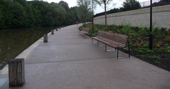 Before the work on the Western Riverside development started, there was a route for pedestrians that went from the side of the Homebase car park, along the river bank to the Victoria Bridge. It was fenced off when the Western Riverside site works first got underway.
In September 2012, Watchdog had been informed by Crest Nicholson that the path has been widened, resurfaced and reopened, so at their invitation we went along to have a look. It is still work in progress in that although the path is wheelchair friendly at the Homebase end there is as yet no wheelchair access to the Victoria Bridge from the riverside path, and wheelchair users will have to leave the path by the same route that they entered it, behind the "Nails" sculpture at the river side of the Hpmebase site. Those who can manage stairs can also leave the path at the other end, beside the bridge. The path will be extended with other exits from it provided as work on the Western Riverside site progresses further.
The section of path in the foreground of our photograph is relatively close to the water level in the river. This has two purposes. It can provide a landing stage for a river taxi service if it such a service is introduced; and it provides water overflow storage when the river is abnormally high, thus reducing the risk of flooding further downstream. It remains private land, and therefore should not be used as unauthorised mooring for pleasure craft, but pedestrians can now use it freely.
Go back to top index
Speed Limits
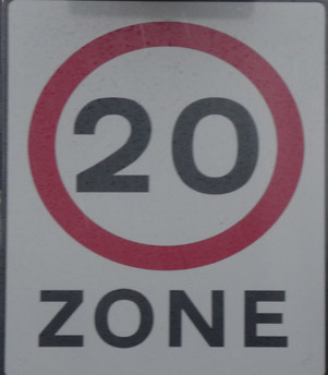 In January 2012, we first commented on the issue of speed limits when we commented on the Chronicle article that councillors were thinking about whether and where 20mph limits might be appropriate in Bath. At the time we noted that according to legislation a 20mph limit is "non-standard" and as such the area thus limited not only needs start and end points but also needs regular reminders ("Repeater signs") at intervals to be enforceable. In a World Heritage City with a desire to de-clutter the street views, we asked councillors to bear in mind the visual impact of all these extra signs. There is also a contradiction in Government Policy where councils are urged to de-clutter streets by one Minister yet are given authority to propose 20mph zones with all the signage that entails by another.
We have now been informed that some areas of Bath have received details of proposals to introduce 20mph speed limits through a wide area of Bath, so it looks as though there is a desire to introduce 20mph zones. It was also pointed out to us that alongside the obvious impact on the World Heritage Site of the visual clutter which was our original concern, we should also consider the hidden damage: the possible detriment to the desire to attract new jobs, an investment the city needs; and the possible impact on tourist numbers, which many trades, accommodation providers, and attractions depend on. In support of these hidden dangers to the character of the city, we were provided with links to some supporting information.
Starting with the survey, households have been sent not much more than a map showing the area proposed along with a response form that trivialises the issues. Will it improve the local environment? It depends on whether repeater signs and road markings are considered visual clutter, and whether the additional fuel burned and exhaust fumes produced because cars drive in a lower gear at 20mph are taken into account rather than just the speed vehicles move. Will it encourage people to walk/cycle more? Buckinghamshire Council's research showed that although people said they would, the actual difference when measured was nil. Will it improve road safety? Generally people instinctively think it will, but the latest research (see below) shows that it makes the situation worse rather than better. There is a more detailed explanation of the theory behind the council's policy on the council website, but the claims in it are rather different from our research.
Portsmouth statistics for 2007 were from the Atkins Report commissioned by the DFT and reported in the Daily Telegraph. This was the only report that separated fatalities and serious accidents (which should be the major concern) from the total including minor accidents; the TRL report was mostly interested in traffic speeds but also looked at the total of all accidents and showed a smaller increase, but an increase nevertheless.
Other Telegraph correspondents identify cyclists going downhill as the most likely offenders breaking a 20mph limit; and that there was a 12% increase in traffic on roads outside the limited zone as motorists found quicker routes for longer journeys; and that the lower speed limit delayed buses causing them to run late to their timetable.
The Portsmouth Council financial report shows that introducing the 20mph limit cost £575,000.
A look through the Portsmouth local press archives reveals a number of reported serious accidents where pedestrians walk into the road in the 20mph zone giving drivers insufficient time to stop.
The Transport Research Laboratory has already done a detailed study of this question at the request of the Department For Transport and this and other expert opinion should be what informs the policy makers. This is especially true when real life has proved that expectations were wrong. The Council website refers to Portsmouth's 20mph speed limit. Portsmouth introduced a 20mph speed limit on 94% of its roads in 2007. Comparison of accident rates before and after the introduction showed a 6% increase in serious accidents afterwards, despite a measured average vehicle speed of 18.5mph and the observation that the speed of the vehicle was only a factor in 5% of the accidents. Between 2007 and 2011, deaths and serious injuries on 30mph roads were reduced, yet in Portsmouth, the figures nearly doubled, from 79 in 2007 to 143 in 2011. Between 2010 and 2011 nationwide, 30mph road casualties reduced by 1% and 20mph road casualties increased by 24%, but by 57% in Portsmouth. The latest advice from the Department for Transport is that local authorities should introduce 20mph limits with extreme caution and only in locations where there was a specific need. The Safe Speed Campaign ("You can't measure safe driving in miles per hour") has now called for a halt to new 20mph zones and formally advises that a 20mph limit does not make the roads safer.
Bath already has a few "Home Zones" with a 20mph limit and 20mph limits outside some schools and these areas appear to match the DfT advice, and there would be a benefit from applying the lower limit outside all schools. Large swathes of 20mph zones do not match the DfT advice, mask the locations like schools where extra care would be appropriate, and the latest research shows that they become more dangerous than leaving the default 30mph limit in place.
For a council claiming to be short of money, there are far better things to spend scarce resources on. The adverse publicity should it later show in the accident statistics that with the introduction of 20mph zones Bath has made its roads more dangerous, is highly undesirable. We have quoted from the Telegraph, but we found similar articles in other national dailies (one of which said that Portsmouth now has the second worst accident record in the UK); and if Bath shows up badly in the statistics in future it will almost certainly be noticed by the press.
Go back to top index
St James Rampire
In June 2010, We commented that a warning of imminent road works has been posted at St James Rampire (ie the roadway outside Abbey Church House), and our recollection is that this location was to be turned into a transport interchange between the BRT route and the regular city buses. We wondered how the council could justify the expenditure at that time. Afterwards we were contacted by the council, who have explained that the work to St James Rampire was part of the Civitas Renaissance initiative, and it is EU funded.
Since then we have dug deeper and not only found on the Civitas website the information on the measures at St James Rampire, but also discovered a council Decision Register Entry, Reference E1770, which says: "Council match funding is €1.225m (£828k at June 07 base) and the proposed match funding will be prioritised in the LTP over the four year period. This has been achieved in the first year by modifying the 10% contingency schemes contained within the £2.144m draft 08/09 LTP Integrated Transport Block programme. Future year LTP programmes will take account of the CIVITAS requirements. ... The project has been subject to a successful PID process and has been approved by the Transport Board. Around 82% of the total Bath funding, €5.313m will come from the European Commission and local partners, €1.225m over four years has to be funded by the Council." In other words in these times of budget cuts Council Tax payers will be contributing just over £1M (the exchange rate has altered considerably since June 07) towards what has all the hallmarks of an expensive mistake. Function has taken a back seat to fashion, and that has consequences.
 St James Rampire now has the same slot drains that have already proved so inadequate in Southgate that heavy rain turns large areas of Southgate into a paddling pool.
 The difference with St James Rampire is that much of the paved area is on a slope (see these pictures), so that when the slot drain is overwhelmed, the water will just keep going. Even worse, there is no slot drain around the base of the lamp post leaving plain paving with no drainage for about a metre. Depending on how heavy the rain is, either the Abbey Church House (pictured right), or the currently empty shop on the corner (pictured left), or both will receive the run-off that doesn't enter the drain.
 And there is the problem! The new paving is higher that it was previously but the buildings remain at the same level. So instead of there being a doorstep protecting the shop, the doorstep is now level with the paving and water will simply cascade into the basement, soaking the ground floor floorboards on the way. Rot will very quickly set in.
![]()
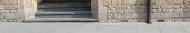 Now consider the Abbey Church House. The picture on the left was taken before the work started (unfortunately on a low resolution camera so the quality isn't ideal) However it is possible to see that there is a wide step below the bottom step, and the air bricks are well above the pavement, which in any case slopes down towards a kerb. The right hand picture shows that the extra step has been covered by the new paving (so where was the Listed Building application for permission to change the external appearance?) and the air bricks (there are three altogether but only two show in the picture) are now at pavement surface level.
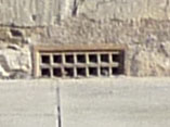 A close-up of one of the air vents (and all three are at the same level) shows that there is an easy passage for water to pour in, so whatever is inside will suffer from wet rot. Even worse, these vents are there for a purpose, which is to allow drying air to circulate inside, so that if they are blocked to keep the rain out, all the flooring timbers will eventually suffer from fungal decay.
EU money is allocated for capital spends. Damages claims for repairs to two listed buildings because of the inadequately considered gimmickry outside will have to be met from Council Tax.
 The final piece of nonsense is the installation of two new lights, referred to as "a new lighting solution". These lights (pictured) are unlike anything anywhere else in Bath, and from a distance they look like an inverted wok containing luminous chick peas. Watchdog has been involved with the Public Realm discussions, so we are aware that one of the items under discussion is a pattern book of suitable street furniture. Watchdog has also noted that in the World Heritage Management Plan the need for suitable street lighting compatible with the World Heritage Site is an objective, and the expectation is that the Public Realm pattern book will contain suitable designs for sensitive areas. We regard the immediate vicinity of the Abbey Church House to be a sensitive area, and the lights installed in front of it to be totally unsuitable.
Finally a quote from PPS25: "Surface water arising from a developed site should, as far as is practicable, be managed in a sustainable manner to mimic the surface water flows arising from the site prior to the proposed development, while reducing the flood risk to the site itself and elsewhere, taking climate change into account. This should be demonstrated as part of the flood risk assessment."
If a tree is to be planted, the type will have to be chosen with care. There are almost certainly Georgian vaults holding up the road surface, and if the tree roots weaken them the road surface is likely to subside.
Before the work took place, there was a large garden area in the middle of a roundabout, and a kerb that blocked water running off from the road from approaching buildings. Now there is no longer the garden area (we understand that a tree is being proposed but that will be insignificant compared with the water absorption capabilities of the former garden), there is inadequate drainage, and new surface water flows that in no way mimic the site prior to the development. The flood risk to the Abbey Church House is increased. Therefore the requirements of PPS25 are not met.
So we have an installation that fails to match the planning legislation, fails to meet national planning guidelines, makes no references to initiatives already in hand and puts at risk listed buildings when previously they were not at risk. We have asked Civitas who is responsible for this debacle. Heads should roll!
[7/11/10] After our report above, The Chronicle obtained a comment from the owner of Abbey Church House that he was unconcerned about flooding.
 Nevertheless, after a few spells of only light rain there is evidence that our concerns were well founded. The picture on the left shows the floor of the former newsagent's shop and the trails of damp across the floor can be clearly seen. The larger grey patch shows where heavier rain washed in cement dust left on the surface outside during the construction. We remain concerned about how much water might enter during a spell of heavy rain and how far through the building it might spread.
This leaves the unanswered question: Who pays for the damage? Is the owner of Abbey Church House "unconcerned" because he expects the council to pay for any flood damage caused by work outside his property? Does this inevitably come out of Council Tax or can the council counterclaim from the contractor who laid the paving, or from Civitas who are the main sponsor (and who have not yet responded to our e-mail)? Or can the Highways Department show that the contractor has not followed the specification and therefore needs to redo the work in order to prevent future damage? Who owns the currently empty shop, and is it now impossible to let because any new tenant runs the risk of water damaged stock? These are not idle questions. Grade II listed buildings should be kept in good repair as Heritage Assets, and with water damage that is demonstrably inevitable given the current layout, somebody will ultimately have to pay.
Go back to top index
Stothert & Pitt Crane
We were alerted to the arrival of a crane manufactured by Stothert & Pitt by an interview the Mayor of Bath gave to BBC Radio Bristol on 16th July 2011. In that interview we learned that the crane is unique, in that it was not built to any particular design, but assembled from parts for Stothert's own use in the Newark Works. Because it was not to a pattern, it has no type name (like the Goliath range) and was simply known as Engine 312. It was due to arrive the following day, to be installed on the Western Riverside as a permanent exhibit of the work of Stothert and Pitt who occupied the site for many years.
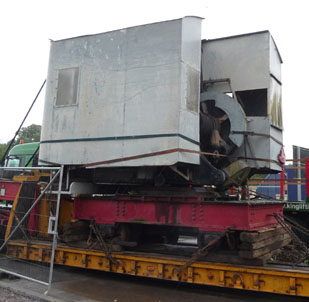 Naturally Watchdog went along with a camera to photograph the crane when it arrived (picture right) along with the jib on a separate trailer (picture below left), and through the activities as it was placed into its exhibition space and reassembled.
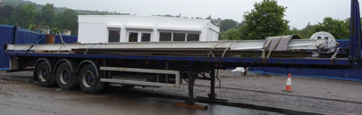 We
also had the opportunity of speaking to the Mayor, Cllr Chalker, and learning a bit more about the crane:
We
also had the opportunity of speaking to the Mayor, Cllr Chalker, and learning a bit more about the crane:
• There is no record of exactly when the crane was made, because many of Stothert's old records were destroyed in various floods plus the bombing of its
offices in 1942, but the most likely date is around 1904.
• When it was first made, the cab would have consisted of just a roof, and the sides that are now fitted probably date from the 1920s.
• It is not known how long it operated at the Newark Works, but at some stage it was transferred to Green Park Station where it worked in the locomotive
depot, becoming redundant when the station closed. In 1971 it was donated to the Somerset and Dorset Railway Trust, where it worked in the Washford yard until 2007 when it failed its boiler safety test. Although repairable, it was not a priority for the scarce funds of the S&D Railway Trust, so it remained idle, and the Trust was happy to return it to Bath where it was built.
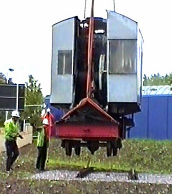 The equipment used to lift the Stothert's crane was able to measure the weight. We were told that this piece (ie without the jib, and with no coal or water) weighed 27 tons. The sleepers and the rails on which it is about to be placed were donated by the Avon Valley Heritage Railway.
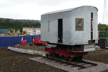 While everything was being put into position, we spoke to the man from the Somerset and Dorset Railway Trust who had been looking after the crane in Washford. He said that the safety failure was because of the rust pitting in one of the boiler tubes, which now needed to be replaced. Whilst not immediately dangerous, it would eventually fail if the crane continued to be steamed, and so the test had failed.
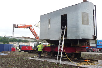 However the test on the boiler showed that it was sound as far as handling the working pressure was concerned, and he had been able to adapt the boiler to received compressed air, which would allow him to operate the controls to position the jib once everything was assembled.
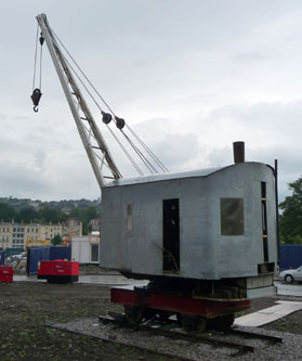 Assembly took place the next day. A rather smaller crane lifted the jib into position (pictured left) and the mounting fixings were secured. The hose trailing from the cab in the picture is the compressed air connection so that the winch would operate.
Our final photo on the right shows the fully assembled crane in position, with the cables attached and the jib raised.
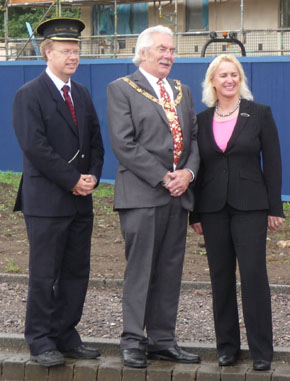 The return of the crane is due to the vision and determination of Heritage Champion Bryan Chalker, but it would not have been possible without the valuable sponsorship of Crest Nicholson who provided the land on which it sits and the transport and lifting equipment to get it on site, or the Somerset and Dorset Railway Trust who were prepared to release their crane back to Bath and prepare it for transfer.
Appreciation is also due to KPH Heavy Transport for getting it to Bath safely, to King Lifting for unloading it, to the Avon Valley Heritage Railway for providing the track complete with GWR fixings on which the crane is mounted, and to the Somerset and Dorset Railway Trust for the presence of Nigel Smart, who knew how to assemble the kit of parts that arrived and how to operate the controls to put it all into a photogenic pose. Watchdog's only contribution was to make the photographic record, a minor service that we were happy to offer.
From left to right in the picture on the left is David Cole representing Avon Valley Railway, Bryan Chalker the Mayor of Bath, and Debbie Aplin representing Crest Nicholson.
Readers might also be interested in the Chronicle coverage when it arrived and when installed while these articles remain available on-line.
Restoration
All the materials for the restoration were donated. Where we were informed of the source, we give credit, but any who we do not mention are equally appreciated, even if we were not given the information.
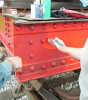 The first stage of the restoration began in August 2011 and was at ground level, preparing and then painting the base on which the crane body is mounted. Several coats of self-priming metal paint donated by Homebase were applied to what is a much larger area than it looks in the photographs, and this treatment should keep the weather and rust at bay for many years.
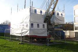 Once the work that could be carried out standing on the ground was finished, Crest Nicholson erected scaffolding and screening so that the higher level work could be carried out in safety. This started in November 2011. It was a trickier restoration, because the cab is made of galvanised steel which cannot be painted with ordinary paint, yet ultimately can rust. Rabart Decorators Merchants (trading locally as Davies of Bath) came to the rescue with a special primer designed for a galvanised surface, and CTM Europe in Cardiff supplied the grey top coat paint. Sharpness Shipyard & Drydock Ltd supplied steel and labour free of charge to replace the roof panels that had rotted through, and then gave it a protective coating of bitumen.
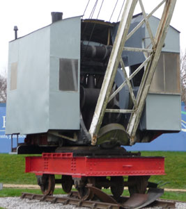 The exterior now completed, the funnel has been capped to keep the rain out of the boiler, and the scaffolding has been removed in February 2012 revealing the first views of the results of all the hard work put in by the volunteers. The paint used for the cab is the same type that was used to paint the Forth Bridge, so it should not need any further attention for at least 30 years.
This picture is the view afforded of the crane once the scaffolding was removed. It is clear from this picture that the jib has not yet been tackled, and arrangements are being made to have it lowered so that it can be cleaned and painted from ground level.
There are still a few items of remedial work still to complete inside the cab. Also the door to the cab has been retrieved from its storage, primed and repainted and is awaiting re-hanging once authentic hinges have been obtained and fitted. Essentially though, by the end of February 2012, the only substantial cosmetic work remaining is the restoration of the jib. Bryan Chalker, the council's Heritage Champion, has aspirations to get the boiler overhauled eventually so that it would be possible to put the crane back into steam for special occasions, but his first priority is to see the cosmetic restoration completed.
Go back to top index
Victoria Bridge
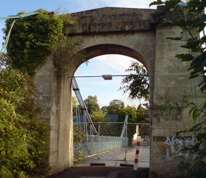 The other piece of news was the closure of Victoria Bridge. Alerted by the Chronicle's news item, we went along to see if there was any observable reason for the closure. Nothing stood out as obvious, but the signs of neglect were everywhere, as the picture on the right shows.
One set of graffiti painted over the top of an older set shows how long it has been since it has been cleaned.
 The stone support for the suspension chain on the left side as pictured must be of dubious strength given the amount of vegetation growing out of the stonework, which can be seen pictured in close-up on the left.
 High up on the other side, buddleia in full flower can be seen through the arch. A close-up shows that this is growing out of the stonework too. Buddleia roots are capable of breaking apart stonework, so the strength of the support for the suspension chains on this side must also be suspect.
Other potential weaknesses can be seen by eye, though they do not show up in photographs. Bumps like molehills in the road surface have been there for years, but they are not caused by moles, they are caused by rust under the tarmac. Some small areas of the suspension chains are now without paint and rust is evident in those places.
It is difficult to reconcile this level of neglect with its listing status. English Heritage have awarded it Grade II*. When designed by James Dredge it was the first ever bridge built to his patented "Taper Principle" (both patent and bridge are dated 1836), and it caused a great deal of interest at the time. In 1840, Lord Western wrote a letter to Lord Melbourne, and copied it to The Times. The following are extracts from that letter (the entire text is too long to reproduce here).
The reason for writing the letter was to support Dredge's offer to repair the Menai Bridge. Dredge's patent was for a design that compared to conventional bridges of the time had a much greater load bearing weight for any given amount of wrought iron - in the case of the Victoria Bridge, 150% compared with conventional bridges was claimed.
Dredge offered to repair the Menai bridge at no cost, having estimated that the value of the reclaimed metal that would be surplus when reconstructed to his design would exceed the cost of rebuilding the bridge. His offer was not taken up.
I cannot refrain from entreating your attention to the vast improvement that has been made in the construction of suspension bridges by Mr. Dredge, of Bath. During a recent residence of two months in that city, I have had an opportunity of seeing often the bridge that has been built by him across the Avon; it is a beautiful structure, and at once commands admiration of its beauty and confidence in its stability. I have communicated with him frequently about it and altogether the consequence has been so strong an impression upon my mind of the vast and immeasurable superiority of the principle on which it is built over anything that has hitherto been attempted...
... Mr. Dredge's statements of the superiority of the power of his system over the established plan of structure certainly, at first, astonished me; he has, indeed, proved, by trials, in the presence of very many persons, a superiority of strength to the extent of at least, 150 per cent. These were made upon small models of bridges, formed severally on the present and on his new principles, each out of the same quantity of iron, but he carries his calculations of the accumulating power derivable from size and extent over and above the 150 per cent, shown upon the small models to such a degree, that I will not venture to state it; but if he should be called upon, in the way, I trust, sooner or later, he will be, to exhibit his system before your lordship and the public, he is confident he can mathematically and practically establish any of the statements he may make, and I have little doubt he will be found to be correct.
... I proceed to give you some account of the expense and particulars of the Victoria bridge, across the Avon, built in 1836, and which has proved itself equal to its inventor's most sanguine expectations; it's cost was £l,650, its span is 150 feet, and only 21 tons of iron were consumed in its construction, which, at £20 per ton, is only £420; the great expense was therefore on the masonry and the timbers supporting the platform or road, which are still of insufficient dimensions and strength, but which, of course, are quite unconnected with the principles on which the bridge is built; the chains are under 10 tons, and are equal to sustain 500 tons on transit.
The Bridge of Oich is listed as Category A. Scottish categories do not exactly match the English listing grades, but Category A (unmodified structure of national or international importance) is compatible with the Grade II* listing of the Victoria Bridge.
According to the paper by Robin Griffiths of Bath University for the Bridge Engineering Conference 2009, Dredge built around 50 bridges to the same design, of which 3 survive today (the most recent loss was the Ballievy Bridge in Northern Ireland which was dismantled as beyond repair in September 1988 and is currently in storage).
 The Victoria Bridge remains as does the unlisted Stowell Park Suspension Bridge over the Kennett and Avon Canal (picture left), and the listed Bridge of Oich (picture right), near Fort Augustus in Scotland, which Historic Scotland advertise as a place to visit. Both are very much better cared for than the Victoria Bridge, yet the Victoria Bridge is the only one easily accessible by the public. It is certainly the only one in a World Heritage Site.
The Stowell Park bridge spans the Kennet and Avon Canal (our picture was taken from a boat on the canal), but the park is private land so walking across the bridge is by invitation only. The Bridge of Oich is a public right of way, but it is in a relatively remote part of the Scottish Highlands and is not easy to visit.
 The Victoria Bridge was the first to be designed by Dredge, and it's construction was completed just 5 months after his patent. Dredge over-engineered the bridge, intending it to remain sound for a very long time, because it was to be used as an example of his design in order to sell more bridges. The advertisement on the right, dated 16 Jan 1843 is perhaps too small to read on a web page, but it includes the statement: The principle was first used by the Victoria Bridge Company over the Avon at Bath, in 1836, in a bridge 150 feet long, and 19 wide. Further down the text he lists seven other bridges built to his design.
The Victoria Bridge is evidently a very important historic structure and fully deserves its Grade II* listing. The fact that the council allowed it to get into a state where even pedestrians are unable to use when it was designed to carry fully loaded brewers drays (Dredge owned a brewery before embarking full time into bridges, and the Victoria Bridge was inspired by a wish to have his cross-river deliveries made quicker and easier) shows an irresponsible dereliction of duty. The bridge must be repaired as soon as possible to a standard compatible with its Grade II* listing. We know that money is tight, but this has more national and international importance than pet local schemes such as bus lanes, and the possibility of grants being available should be explored. Those council members who wince at the cost should bear in mind for the future that regular routine maintenance always costs less in the long run than emergency repairs after a period of neglect.
Go back to top index
Wayfinders
Wayfinders are facilities provided to the public so that those unfamiliar with the location can find their way to public attractions and key locations. Technically, finger posts are wayfinders, but here we are initially only commenting on the maps.
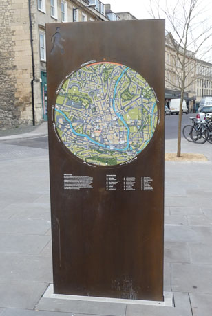 The
type of wayfinder being installed in Bath is pictured on the left. We know that the map inserts are temporary while consultations suggest improvements, so we make no comment
on the map itself at this stage.
The
type of wayfinder being installed in Bath is pictured on the left. We know that the map inserts are temporary while consultations suggest improvements, so we make no comment
on the map itself at this stage.
 However, our attention was drawn to what was described to us as a "nicer" looking map seen in Wells (pictured right). So we examined it to see what might be considered nicer.
The Wells one tells you where you are ("Sadler Street" in this case) and there is a clear "You are here" marker on the map. To be fair, the Bath one also says that, but not in such a prominent way.
The Wells one has got "City of Wells" and the city Coat of Arms on it. The Bath one doesn't carry anything similar, so its designer clearly wasn't proud of Bath.

 The Bath Coat of Arms (left) is attractive and would enhance the map, even if it was necessary to reproduce it in monochrome for technical reasons.
The image on the left is above the new maps; the one on the right is from the Emergency Exit signs defined in BS5499 and converted from the specified green to monochrome. Although not identical, they are similar enough for the association to be made.
 Also, where is the World Heritage symbol (right) which when picked out in gold on a dark background would show that Bath takes some pride in that accolade?
The point of the silhouette of the man who has escaped from an "Emergency Exit" sign (see box on right) is not obvious, and this gimmick is no substitute for signage demonstrating pride in one's city.
Finally, the Wells one is mounted on poles and is at the back of the pavement, so that backdrop of a solid wall leaves the impression of it being more dainty than the Bath one, despite the map itself being bigger. The thing that makes the Bath one appear so solid is the rectangular shape going all the way to the ground, and the positioning which makes it look like a barrier.
 The Bath one does have the advantage of a map on both sides, but we have so rarely seen both sides in use simultaneously that we wonder whether that benefit outweighs the risk of somebody walking into it whilst looking around and talking. We waited until the summer of 2011 to see it
actually happen, but but before that there have been a couple of observed near misses before that. Young children especially don't always look where they are going!
The Bath one does have the advantage of a map on both sides, but we have so rarely seen both sides in use simultaneously that we wonder whether that benefit outweighs the risk of somebody walking into it whilst looking around and talking. We waited until the summer of 2011 to see it
actually happen, but but before that there have been a couple of observed near misses before that. Young children especially don't always look where they are going!
Judging by the low level staining, the Bath style one is also irresistible to dogs wishing to empty their bladders. The choice of a material that reacts to this occurrence by showing discolouration stains was clearly not a good one. Frequent routine cleaning will be needed.
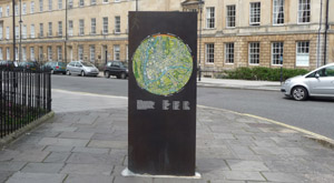 The council has an adopted Streetscape Manual which includes the objective "Ensure that permanent or non-permanent elements installed on pavements minimise obstructions for pedestrians." The fingerposts did, and the Wayfinders positioned broadside on to the pedestrian flow certainly do not, with some being installed in the centre of the pavement width even on much narrower pavements than the one in our
picture, taken at the end of August 2012.
The council has an adopted Streetscape Manual which includes the objective "Ensure that permanent or non-permanent elements installed on pavements minimise obstructions for pedestrians." The fingerposts did, and the Wayfinders positioned broadside on to the pedestrian flow certainly do not, with some being installed in the centre of the pavement width even on much narrower pavements than the one in our
picture, taken at the end of August 2012.
Soon after this protograph went on line we were contacted and informed that the Wayfinder we showed in our picture had been moved, so we went along to have a look in early September 2012. Yes it had been moved from the Pulteney Street pavement, and now sat near the Bike In Bath racks outside the Holburne.
 The
paving that filled the hole where the Wayfinder used to be in Pulteney Street had been restored using suitable stone, which is the good news (though it must have cost money). The bad news is that the maps on the repositioned Wayfinder have not been updated, so the "You Are Here" locator is now a "This is where you would have been if it hadn't been moved" indicator which has to potential to confuse. What tourists will think of the scruffy, trailing bubble-wrap that fills the gap at its foot is anybody's guess.
It was replaced by a more solid cement surround just over a week later.
The
paving that filled the hole where the Wayfinder used to be in Pulteney Street had been restored using suitable stone, which is the good news (though it must have cost money). The bad news is that the maps on the repositioned Wayfinder have not been updated, so the "You Are Here" locator is now a "This is where you would have been if it hadn't been moved" indicator which has to potential to confuse. What tourists will think of the scruffy, trailing bubble-wrap that fills the gap at its foot is anybody's guess.
It was replaced by a more solid cement surround just over a week later.
Finger Posts
In 1986, Bath City Council commissioned a study into the 'Economics of Tourism'. A Tourism Marketing Strategy was adopted by the City Council in 1995. These forerunners were carried forward into subsequent Local Plans, and in 2006 the council further endorsed these aims in the Local Plan adopted that year which describes visitor facilities. It includes the statement "The City Council is seeking to improve the level of information at additional points throughout the City ... This is being brought forward along with a rolling programme of new street furniture and new directional finger post signs." (The underlines are our emphasis). Despite the Local Plan being superseded by the 2007 Version which encourages visitors walking but is less specific about how visitors should navigate their way around, and that in turn will be superseded in time by the Core Strategy which simply says that Bath should be a place that is easy to find your way around with excellent walking and an uncluttered streetscape. However our search of council minutes and policy documents has failed to reveal any which indicate that the underlying adopted policies of directional finger post signs have been revoked.
 Despite the obvious convenience of the finger posts (Look up, read the signs even from a distance, and walk in the direction indicated) they had almost disappeared in the centre of Bath during the second half of 2012. Instead, those seeking directions have to refer to the maps on the pavement-blocking Wayfinders, or more commonly ask somebody (which is generally quicker and doesn't require the elderly to crane their neck to see the top of the map through the bottom half of their bifocal spectacles).
Obviously, whoever made the decision to replace the finger posts with Wayfinders has taken action without the appropriate public consultations on changing the adopted policies, which makes it inappropriate action. Nor has any empathy with tourists wishing to take heritage photographs been shown.
Those finger posts which survived to the end of 2012 remained until late summer of 2013, when the two survivors in the Union Street and Stall Street area were removed: the first at the end of September 2013 and the second a week later.
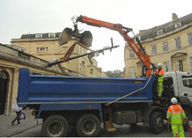 A supporter sent us a few photographs with permission to reproduce them here. For a council that has said it is short of money, this appears to be wholly unnecessary expenditure. No doubt at some stage money will be further wasted when another pavement-blocking "Wayfinder" will be installed instead.
Yet a new wayfinder would be contrary to council policy because the Streetscape Manual has an objective to "minimise obstructions for pedestrians", an objective endorsed in the draft Core Strategy. It is only necessary to watch what happens in Manvers Street when several of those arriving on a train and wheeling their suitcases past Lewis House meet someone pushing a baby buggy in the opposite direction past that wayfinder to see the wisdom of the objective and the unfortunate consequences of ignoring it.
New finger posts are explicitly mentioned as the method of improving informing visitors, as part of a another formally adopted council policy which has not been revoked. It is also noticeable that whilst a finger post can be easily viewed and followed by anybody, the wayfinder map is difficult, if not impossible to read for somebody seated in a wheelchair, and poses problems for those with impaired eyesight who need reading glasses for the wayfinder maps but do not have them handy. Thus finger posts are being removed which are of more use to the disabled than the replacement wayfinders, and this means that the council has committed an illegal act, because the Equalities Act 2010 forbids substitutions which make life more difficult for the disabled. We can only hope that the finger posts that have been removed have been put into store and are not already melted down for scrap, so that if a court ever orders their replacement under that Act, they can just be restored to the streets and there is no need to have replacements made. It would be a criminal waste of taxpayers' money if new ones had to be manufactured rather than reusing the old ones.
Meanwhile, residents can now expect more occasions where they are asked for directions now that the helpful finger posts are gone.
Perhaps the council should consider whether a consultancy fee should be payable for each occasion that such services are rendered. [Joke!]
Go back to top index
As Others See Us
Background
From time to time we read something or speak to someone which gives a visitor's eye view of Bath. Originally we just mentioned them on the front page of our website, but it has been suggested that we put them in one place as an easily accessible reminder. So here they are, with the most recent on the top and going back in time as you read down.
- From an Architecture Journal - Recorded here 15th January 2012.
- Building.Design is an architectural journal with an on-line presence BDOnline. Unfortunately many of its articles are only available to registered users (and Watchdog is one), but it does allow extracts to be reproduced for educational purposes so rather than providing a link to the article, we reproduce the essence of what was said here (the bdonline copyright restriction does not permit the full article to be reproduced verbatim). The article does not mention the location, but it is clearly the Southgate shopping centre.
I went to Bath to enjoy a few days there in the run up to Christmas. Having had a mostly pleasant experience looking at the Roman ruins, as well as walking around the famous Royal crescent and nearby park, I was left pondering the concept of pastiche and why so many "modern" people - me included - find it unappealing.
A reconstituted and wholly inaccurate history lesson can be observed when walking from the citys main bus station, towards the centre of town where faux-Georgian styled "architecture" is used to wrap food, clothing, and mobile phone outlets. Uncompromisingly modern retail frontages that crouch uncomfortably behind ultra-thin colonnades and limestone cladding are the unsettling outcome of using half-baked "look-a-likey" details lifted directly from misremembered visits to local Georgian or Victorian high streets and townhouses.
An abundance of what looks like local limestone and period decoration should bring a weighty authenticity to proceedings, as well as garnering admiring glances from all that pass by. However, when the meat in this architectural sandwich is comprised of steel-reinforced concrete boxes wrapped in monotonous cladding, devoid of natural variation, adorned with awkwardly proportioned columns and pediments - quite obviously shaped to disguise the steel I beams hidden within it becomes a very unappetising proposition.
The presence of modern technology - enabling spans of frameless glass that would seem impossible to 18th or 19th century designers not to mention the combination of mandatory building standards and penny pinching developers, with their clunky Juliet balconies, are at odds with the ethics of their Georgian forebears. Ethics that once upon a time embraced and promoted the value of huge elegantly proportioned windows to let the sun in and high ceilings for the spirit to soar. Genuine philanthropy was at work in these parts a couple of hundred years ago - not any more.
I guess the problem with this pastiche then is that it is dishonest, stifles creativity and ergo a kind of urban paralysis ensues.- Spoken Comment - Recorded here 4th December 2011.
- Last week Watchdog was invited to meet a professor from a School of Architecture in Rome, researching a book he intended to write on modern interventions in heritage locations. After a meeting hosted by the Bath Preservation Trust, we took him on a guided tour of the locations that had been discussed.
- He had a grudging admiration for Waterside Court as "honest even if inappropriate", and thought that Charlton Court next door "recognised its sense of place". He was not complementary about the Western Riverside ("too cramped and blocky") and had mixed views of the Technical College where the Refectory (Allen) building was "a well designed unashamedly modern addition" compared to the Welcome building which was "pointless fashionable gimmicry". The shops on the east side of Avon Street opposite the Welcome building were praised for "understated elegance". Both the Holburne extension and the Thermae Spa building received the same criticism, "stone is supposed to be an external surface and placing it behind glass is all wrong", though in addition the Holburne extension was "top heavy". Both the new Georgian style addition to St George's Place and the latest additions to Bathwick Street were "good looking replicas" but he did observe that the former with its timber frame would have a much longer life than the latter with its steel frame. The Podium was "reasonable" and the Post Office building "excellent", as was Seven Dials.
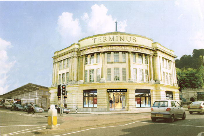 He was not impressed with Southgate, dismissing most of the shopfronts as "too big, and featureless" and pointing out that the grand pedimented facades should look out on a straight avenue or on a similar facade and none of the Southgate ones do because they are "all at the wrong angle", proving that "whoever designed it had no idea of the classical language he was trying to imitate". He thought the layout was "an opportunity missed" because "it has no focus". Little Southgate was "the obligatory featureless arcade" that made him want to hurry through rather than stop and look. The "Busometer" was dismissed with a "who thought that was a good idea?", so we gave him this picture of Churchill house and told him about the petition.
- He took lots of photographs and promised to keep in touch, so it will be very interesting to see what is included in his book when it is published.
- From an Internet Forum - Recorded here 18th September 2011.
- Sometimes when searching for information on the internet, among the things offered to look at are items which appear to fit the search criteria but are actually about something completely different entirely.
- Once such chance discovery was encountered researching an item for Watchdog's website update. The quote in the box on the right came from an international discussion forum for young tourists, part of a reply to a request for advice on visiting Prior Park Gardens.
- The quoted advice has gone round the world. We thought it worth repeating so that our readers know how some potential visitors regard Bath.
- (Second) Best Small City - Recorded here 17th April 2011.
- As reported in The Chronicle, Bath came second in a poll to find the best small city in Britain, beaten by York.
- York's local press gave slightly more information, revealing that along with history and architecture (which Bath also has) the praise was for the general feel of York. A Watchdog member who lives in Bath but is a regular visitor to York gave us an insight: York has banned bendy buses from the centre, so that those few that still run are restricted to the outskirts. York also has nearly completed the process of banning "A" boards from the pavements and does not permit tables and chairs on the public streets, and certainly would never allow temporary exhibitions to spoil the view of photogenic buildings. The result is a city that is tidy and uncluttered, allowing pedestrians to look around rather than watch for the next obstacle in their path.
- There are lessons to be learned there perhaps, if Bath has aspirations to be more than a runner-up in future.
- World Heritage - Recorded here 6th March 2011.
- Anyone watching The Culture Show on BBC2 on 3rd March 2011 will have seen Richard Brooks, the Arts Editor of the Sunday Times, talking about Britain's World Heritage Sites. This is what he had to say about Bath:
- The City of Bath is quite unusual because the whole of the city, this great Georgian gem, is designated a World Heritage Site. UNESCO expressed some concern, gave it a yellow card warning about too much modern architecture being placed too near the Georgian heritage of this great city.
- This is what he had to say about world heritage in general:
- UNESCO says the World Heritage Sites are meant to belong to all the peoples of the world irrespective of the territory in which they are located. They are meant to be sites for the world to view not just the British people. They are of world importance. They are meant to be of outstanding value to humanity. Are we really in Britain doing our bit to ensure that they live up to this status; that they are world value sites that Britain has.
- This was broadcast on national TV at prime time. The implication of the programme was that Bath (among others) has allowed the heritage it was entrusted with to be downgraded by inappropriate modern architecture. We have repeatedly expressed our concern about planning decisions being made without considering what the world at large might think of the outcome. For instance, the outline application for the Western Riverside was granted permission despite the tower blocks being incompatible with the Western Riverside SPD and despite UNESCO asking for "a time-bound revised plan for the second and third phases of the Bath Western Riverside project, including revised density and volume of the ensemble".
- The programme did not say that Bath's worst excesses have not yet been built, so those watching the programme are likely to conclude that the damage has already been done. What impact this broadcast might have on those considering a visit to Bath remains to be seen. One thing is clear though: those who make planning decisions for Bath need to pay far more heed to the wider consequences of their decisions, in the knowledge that the world is watching what they do; and judging from this programme, the world doesn't like it.
- UNESCO Visit - Recorded here 19th July 2009.
- The state of World Heritage is overseen by the World Heritage Committee, which meets annually, to review reports of the condition of World Heritage Sites submitted by "The State Party", meaning the representative of the government responsible. In Bath's case, this is DCMS.
- Some things in the DCMS report discussed in the 2008 meeting let the committee to initiate "Reactive Monitoring", which means taking an independent look. In November 2008 a representative of UNESCO and a representative of ICOMOS visited Bath, and then submitted their full report to the 2009 meeting, thus giving a much greater insight into how the Mission presented Bath to the Committee in Seville.
Bath is beautiful, but it will cost you an arm and a leg to stay there, or even more to (dare I say it) PARK there for a day. You might as well just open a vein.... or park illegally and just pay the fine, its probably cheaper than the standard parking charges.
Go back to top index
Facadism
Facadism has been described in one architectural journal as "The unfortunate practice of destroying everything apart from the front wall and constructing a new building behind it". Another architectural publication described the result as "architects are humiliated into creating passive-aggressive structures - gross hybrids of conflicted intentions that scream 'Look what you made me do!' in bitter petulant resentment". We think this last comment goes a bit too far. In our experience, architects initially assume that they will be looking at a demolish and rebuild scenario, and so if there is a planning condition that part of an original structure should be retained, little or no attempt is made to incorporate it in a development other than as a freestanding relic of the past. The VAT regulations are partly to blame: demolition and building new is often zero rated VAT, whereas 5% or even 20% VAT is often assessed on building re-use, so there are cost and profit implications too.
Realistically, there shouldn't be a need to grant permissions with facade retaining conditions. Listed buildings are supposed to be preserved with the minimum of modifications commensurate with providing a viable future use according to the NPPF which treats all listed buildings the same "irrespective of whether any potential harm amounts to substantial harm, total loss or less than substantial harm to its significance"; and full or partial demolition decisions should be wholly exceptional. The NPPF also expects Local Authorities to ensure that where harm to a heritage asset is to take place, there should be measures in place to ensure that the development does take place after the harm has taken place. Even non-designated heritage assets (such as the Bath Press building) are afforded significant protection in the NPPF.
The NPPF defines World Heritage Sites as having the highest significance because they are internationally recognised as an irreplaceable resource, yet planning decisions have seldom heeded that constraint, and even when the World Heritage Committee urged "The State Party" (officially DCMS but in reality B&NES) to redesign Phases 2 and 3 of the Western Riverside Development to make if more aligned to the Outstanding Universal Value of the World Heritage Site, this was totally ignored.
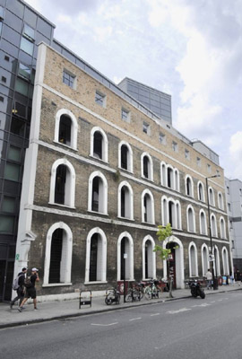
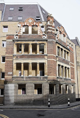
The first of the photos by The Gentle Author (on the left) was a structure that won the Carbuncle Cup in 2013. The original building was an 1874 warehouse. The building it now masks is UCL student accommodation.
The second such photo (on the right) shows what remains of the Cock & Hoop public house, opened in 1805 and reduced to a blank facade in front of LSE student accommodation in 2006.
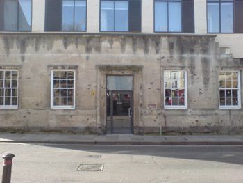
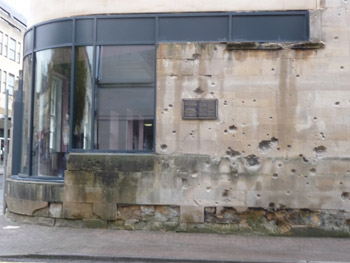
Bath's student accommodation required the destruction of the interior and roof of a listed building with just the front and side facades preserved. The architects did avoid a visible gap by abutting the building inside to the preserved walls, though without the weight of the roof holding the old walls in compression, minute cracks can now be seen when viewed at close quarters.
Finally, there are the freestanding facades waiting for the rest of the development to take place. On the left is the frontage of the Grade I listed National Provincial Bank, built in Threadneedle Street in 1863. As a Grade I listed structure such destruction should have only have been permitted in exceptional circumstances, but look at it now!
On the right is the facade of what was originally called The Pitman Press and later The Bath Press, located on the Lower Bristol Road in Bath. This was defined by Historic England as a Locally Important building. We tried to persuade the developer to retain part of the original building behind the facade so that it belonged to an area that could have been useful local shops for the housing and offices to be built on the rest of the site. This fell on deaf ears, both of the developers and of the council planners.
Go back to top index